Noting a return of readers to my blog today, probably looking for New Zealand earthquake analysis, I will rattle this post off quickly, as a catch-up on a previously strong theme to my writing. Then I will take a good long walk to relax. As should we all.
Having accurately forecast, to within 50 minutes, a magnitude 4.7 Christchurch earthquake yesterday, what are my afterthoughts about this? Under-earth events continue for the country and are detailed here: “#Masterton mag 5.2 #eqnz this morning is not alone..”[1] (Read research at footnote link). The title is only more fitting, a month to the day since it was written, when there have been two 5.2 magnitude earthquakes, this new morning. (Ironically, says the Moon Man?)
Stunning, really. Awesome Earth!
But what is the big picture, if I am asked?
Well, it’s not good. Not for New Zealand, one of the newest land masses and nations on the planet – it is likely to have to start again. In our lifetime? It seems / I would say, perhaps yes. Because a 330-year Alpine Fault cycle is sitting at year 299, approximately.
The tectonic motion we have begun to experience as a constant factor of the post-colonial state has the capacity to practically destroy it. In my opinion. A catastrophe so large is built into this land, Aotearoa – Land of the Long White [volcanic] Cloud – that it will surely cripple us one day. Soon? Hard to say. Why? It looks like this:
Current south-east/central North Island quakes are signs that the Australian Plate it is on is moving, a little bit more. When it finally gets going properly it will be a huge leap south-east, and this will spread the central plateau / Kermadec Arc enough for the Taupo super-volcano to explode again. That will obliterate the central North Island and disable both Auckland and Wellington.
What will initiate this calamity, however, will be almost as bad for the South Island – a magnitude 8+ slippage of the Alpine Fault, disabling Christchurch and the then-isolated West Coast. This (long-term) ‘regular’ event constitutes the letting-off of the not-quite slow-moving tectonic brake, that is the Southern Alps, that keeps this geological system ‘stable’. A relative term. Long calm will resettle again, after many many large and small aftershocks.
Will Otago-Southland be left standing to pull us through? Let us hope so.
There is no way we can recover from this imminent (in our lifetime?) surety without massive international support and massive sacrifice of sovereignty.
Let us prepare for that transitional step now. However we are best able to.
But it may be that the next magnitude 8+ Alpine Fault earthquake does not release Taupo super-volcano.[2] Let us hope so. ‘Not yet please.’ We are not ready. …
Is the Taupo volcano on a 5, 6 or 7 Alpine Fault-slip cycle? Some decade on from now, all New Zealand will be discovering this, as-yet hidden fact, together. It will be our darkest hour. Human spirit will pull through.
Kia kaha. Kia ora. Waimarie.
[1] facebook.com/photo.php?fbid=10209826325001836&set=a.1294734535479.2045005.1443783772&type=3
[2] “1800 years ago Taupo volcano in New Zealand had the largest volcanic eruption in the world for the last 5000 years.” sott.net/article/249473-Is-The-Super-Volcano-Taupo-in-New-Zealand-Awakening and see wikipedia.org/wiki/Taupo_Volcano “The main pyroclastic flow devastated the surrounding area, climbing over 1500 metres (5000 ft) to overtop the nearby Kaimanawa Ranges and Mount Tongariro, and covering the land within 80 kilometres (50 mi) with ignimbrite from Rotorua to Waiouru. Only Ruapehu was high enough to divert the flow.”
“Possibility of further eruptions on White Island remains high” 10 May 2016 m.nzherald.co.nz/nz/news/article.cfm?c_id=1&objectid=11636672
“Mt Ruapehu still shaking” – top closed to public radionz.co.nz/news/national/303667/mt-ruapehu-still-shaking
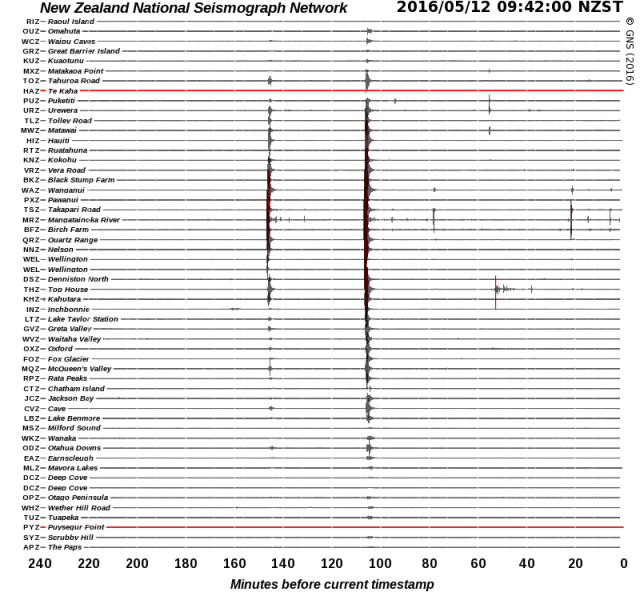
“Aggressive 4.7 Christchurch shake centred close to February 22, 2011 earthquake” stuff.co.nz/national/79890087/earthquake-rattles-christchurch and five hours later a “‘Strong’ earthquake shakes lower North Island” stuff.co.nz/national/79892918/Strong-earthquake-shakes-lower-North-Island 12 May 2016 – graphic, GeoNet.org.nz/quakes/drums:
Update 30/5/2016
Scientists prepare for Lake Taupo eruption
“A team of researchers is studying the volcano so better response plans can be put in place in case of a large eruption. The Earthquake Commission said damage from the last time the volcano erupted – almost 1800 years ago – would be large enough to destroy the central North Island…”
radionz.co.nz/news/regional/305214/scientists-prepare-for-lake-taupo-eruption
Understand that the Taupo Volcanic Zone, stretching from Mount Ruapehu to north of White Island, marks the southern pin of the broad Kermadec Arc and basin, a massive slow-spreading rift in the Earth that forever thins its crust. From this steady motion – eastwards, of the Australian Plate – re-eruption of Taupo Volcano is inevitable. It isn’t the centre of the North Island for no reason – it explains why the island is above water. https://en.wikipedia.org/wiki/Taupo_Volcanic_Zone

Subduction Zone diagram
https://en.wikipedia.org/wiki/Lau_Basin + Graphic: https://en.wikipedia.org/wiki/Back-arc_basin
The 5th most explosive volcano event known to human scientific records:
Name: Whakamaru
Zone: Taupo Volcanic Zone
Location: New Zealand, North Island
Notes: Whakamaru Ignimbrite/Mount Curl Tephra
Years ago (approx.): 340,000
Ejecta bulk volume (approx.): 2,000 km³
https://en.wikipedia.org/wiki/Supervolcano#VEI_8
Later, “Earth’s most recent eruption reaching VEI-8, the highest level on the Volcanic Explosivity Index” https://en.wikipedia.org/wiki/Taupo_Volcanic_Zone –
“The Ōruanui eruption (about 26,500 years ago) covered much of the central North Island with ignimbrite, up to 200 metres deep. Ash fallout was spread by the wind over the entire North Island, much of the South Island, and a large area east of New Zealand, including the Chatham Islands. About 1,200 cubic kilometres of pumice and ash were rapidly ejected. This caused a large area of land to collapse, forming the caldera basin now filled by Lake Taupō.”
…”Big bang – The Ōruanui eruption was so enormous that it is hard to visualise. In only a few days or weeks it ejected enough material to construct three Ruapehu-sized cones. After the eruption, the new lake gradually filled to a level 140 metres above the present lake. The lake broke out to the north, resulting in a huge flood. For several thousand years the Waikato River flowed northwards into the Hauraki Gulf, but it later changed its course to flow through the Hamilton lowlands to the Tasman sea.”
Then, …”Taupō eruption – The most recent major eruption of Taupō volcano took place in late summer–early autumn around 200 AD, from vents near Horomatangi Reefs (now submerged). The eruption produced a towering ash column, resulting in tephra-fall deposits over a wide area from Hamilton to Gisborne. The airfall deposits were much thicker to the east of Taupō because the eruption column was blown in that direction by strong westerly winds. The eruption column was followed by a devastating pyroclastic flow, blanketing a roughly circular area within 80 kilometres of Lake Taupō with ignimbrite, and destroying all life in its path. The ground-hugging pyroclastic flow appears to be one of the most powerful ever recorded, and was able to overtop Mt Tongariro and the Kaimanawa mountains, climbing 1,500 metres in a matter of minutes. The outlet of Lake Taupō was again blocked during the eruption, and the lake level rose to 34 metres above its present height, forming a widespread terrace. The lake eventually broke out in a huge flood whose effects can be traced for over 200 kilometres downstream, and include boulder beds and buried forests.”
http://www.teara.govt.nz/en/volcanoes/page-5
That is, the same most recent was, the ‘Hatepe eruption’: “considered New Zealand’s largest eruption during the last 20,000 years.. ejected some 120 km3 (29 cu mi).. of which 30 km3 (7.2 cu mi) was ejected in the space of a few minutes. This makes it one of the most violent eruptions [on Earth] in the last 5000 years.. Tsunami deposits of the same age have been found on the central New Zealand coast, evidence that the eruption caused local tsunamis” https://en.wikipedia.org/wiki/Hatepe_eruption
“Radiocarbon dating indicates an uneven spacing of Taupo’s eruptions, from decades to thousands of years apart. This makes it difficult to forecast when the next eruption will occur and how big it will be.” http://www.teara.govt.nz/en/volcanoes/page-5
http://hisz.rsoe.hu/alertmap/index2.php#supv
http://quakes.globalincidentmap.com
http://www.emsc-csem.org/Earthquake
Update 4/6/2016
“Magma chamber blamed for Bay of Plenty earthquake swarm.. study found the previously unrecognised magma body caused several thousand small earthquakes between 2004 and 2011.. expansion of the molten rock chamber approximately 9km below Matata has pushed up 400 square kilometres of land by 40cm.. something was accumulating at a depth of around 9.5 to 10km beneath the Earth’s surface.. The magma body could have been there for centuries or more.. The area was a ‘rift zone’ where over time the crust had been stretched and thinned – but it was not clear whether the crust was already thin, or the magma made it thin. ‘It is probably a thinner crust than the average you’d find elsewhere.. But what happens is as you stretch the crust and the hot rocks beneath come to a shallower depth, as they become shallower they get less pressure, which actually then enables them to melt and become magma. That magma, because it’s less buoyant than the surrounding rock, it then wants to percolate up through [into the crust]'”, RNZ – radionz.co.nz/news/national/305592/magma-buildup-blamed-for-quakes & Science Advances article, “results suggest that the continued growth of a large magmatic body may represent the birth of a new magma chamber on the margins of a back-arc rift system” – advances.sciencemag.org/content/2/6/e1600288.full
“A huge deposit of magma has been detected just 9km below a small North Island town – and scientists say it may be causing earthquakes. Matata is nestled between Tauranga and Opotiki, and new research using satellite image, GPS data and surveying has revealed the molten secret. The level of the town has been steadily rising over the last few years – up to 10mm per year of uplift, but it is now beginning to slow to about four-five millimetres per year. Scientists are confident there will not be an eruption in the near future, but say they will continue to monitor the magma field”, TV1 – tvnz.co.nz/one-news/new-zealand/huge-field-molten-magma-found-under-north-island-town
“Rising magma to blame for swarm of quakes”, TV3 – newshub.co.nz/nznews/rising-magma-to-blame-for-swarm-of-quakes-2016060400
“Volcano status and notifications come to the GeoNet app – With the flurry of volcano activity last month, we’re pleased to add some new features to the GeoNet app so you can keep an eye on them, too”, GNS 30May2016 –
info.geonet.org.nz/display/appdata/2016/05/30/Volcano+status+and+notifications+come+to+the+GeoNet+app
Update 17/6/2016
Lake Tarawera water warning, 10 Jan 2015 – “People are being warned not to drink water from Lake Tarawera or swim in it after locals noticed the water was discoloured. It was reported to the Bay of Plenty Regional Council yesterday by Hot Water Beach residents. The council says geothermal activity could be to blame for the water’s white, milky appearance. Samples have been taken to test for the presence of algal blooms. The results are not due back until next week.”
http://www.newshub.co.nz/nznews/lake-tarawera-water-warning-2015011012
Lake Tarawera tests positive for algae, 15 Jan 2015 – “Lake Tarawera has tested positive for potentially toxic blue-green algae, but a health warning will not be issued. The confirmation comes after samples were taken from the lake last week, as well as Te Rata Bay near Hot Water Beach. The lake is at ‘amber alert’, meaning the situation will continue to be monitored. ‘The blue-green algae identified are potentially toxic but the levels of algae are below health guidelines,’ says Bay of Plenty Regional Council science manager Rob Donald. ‘We recommend that people do not swim in the water if it is discoloured.’ Blue-green algae only recently arrived in New Zealand, but has already taken its place in lakes throughout the North Island. It causes water to appear green and cloudy, and sometimes green specks will be visible.”
http://www.newshub.co.nz/nznews/lake-tarawera-tests-positive-for-algae-2015011517
Mt Tarawera vent erupts after 35-year slumber, 17 Jun 2016 – “One of the geothermal vents in Mt Tarawera’s Raupo Pond Crater came alive for the first time in 35 years last month, according to GeoNet. The Mud Rift feature — a 6m-wide, 36m-long, 15m-deep vent formed in 1906 that has been lying dormant since 1981 — was activated sometime between May 17 and 20 this year. A blog on the GeoNet website suggests the eruption was a fleeting event, and involved fluids flooding into the vent and causing ‘stress and browning off’ of surrounding plants. It says the eruption was mainly steam-driven, and involved plenty of water, creating what has been likened to a ‘muddy geyser’.”
newshub.co.nz/nznews/mt-tarawera-vent-erupts-after-35-year-slumber-2016061716
Update 27/7/2016
It appears this blog post has been read and authorities are now responding:
stuff.co.nz/national/82524357/team-granted-funding-to-plan-response-for-alpine-fault-megaquake
– Noting that a Megaquake could hit central New Zealand, Stuff 19 May 2015, motivating research like Simulation of a Magnitude 8.4 Megathrust Quake in New Zealand, GNS Science youtube, 12 November 2015

Stuff graphic – “Megaquake could hit central New Zealand” – 19 May 2015


